Reviews Contact WhatsApp Logo Viber Logo +977- 9849430866
Simrik Nepal Treks
Simrik Nepal Treks

Tashi Lapcha Pass Trek

18 Days
|
81 Reviews
Starting from
USD. 4860.00
Trip Details
Itinerary
Inclusion and Exclusion
Equipments & Packing List
Trip Maps
Trip Details
Destination
Nepal
Trip Grade
Challenging (Advanced Level)
Max Elevation
5755 Meters
Total Duration
18 Days
Best Time
March-May|September-December
Group Size
Min 2 Pax

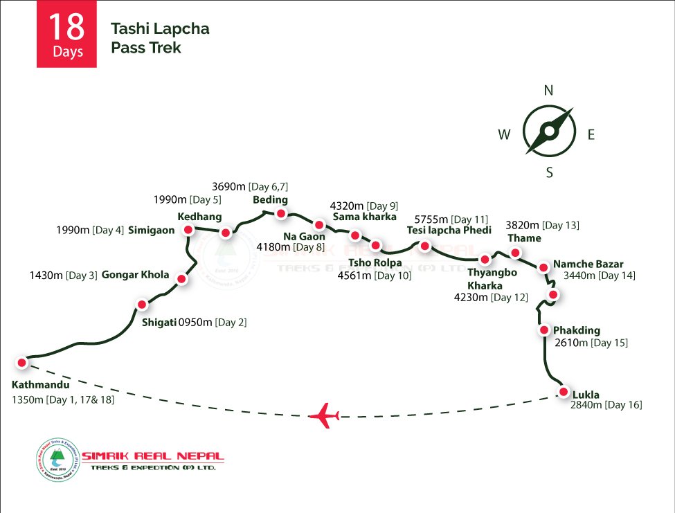
Tashi Lapcha Pass Trek|A Remote High-Pass Odyssey from Rolwaling to Everest

Embark on a once-in-a-lifetime Himalayan adventure through the wild and remote Tashi Lapcha Pass Trek—one of Nepal’s most challenging and awe-inspiring Trek experiences. This exhilarating trail connects the mystical Rolwaling Valley to the legendary Khumbu region, crossing the dramatic Tashi Lapcha Pass at 5,755 meters, where serenity, solitude, and raw natural power converge. Ideal for seasoned trekkers and wilderness enthusiasts, this expedition-style journey reveals a rich mosaic of alpine landscapes, traditional Sherpa settlements, glacial lakes, and mythical legends from deep within the Himalayas.

Key Highlights of the Tashi Lapcha Pass Trek

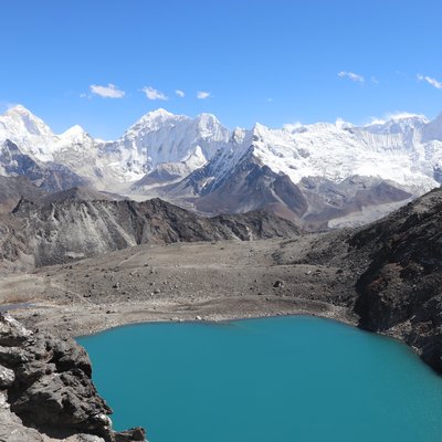
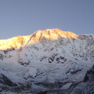
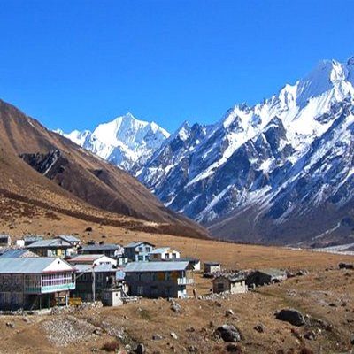
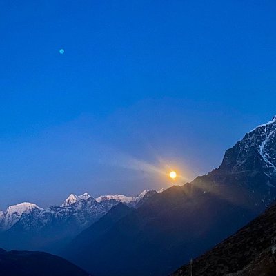
Traverse the pristine Rolwaling Gorge, often referred to as “The Grave” in the local Sherpa dialect, due to its secluded and dramatic terrain. Witness panoramic views of Gauri Shankar, Pharchamo Peak, Dorje Lakpa, Yalung Ri, and the rarely seen Rolwaling Himal. Explore high-altitude landmarks such as Tsho Rolpa Lake, creaking glaciers, and the breathtaking glacial amphitheater near the pass. Immerse yourself in the time-honored Sherpa culture—from hillside hamlets to centuries-old Buddhist monasteries nestled in tranquil mountain settings. Experience rare solitude and spiritual tranquility, far from the crowded trails of the Everest Base Camp route.

At Simrik Nepal Treks, we bring two decades of experience guiding trekkers across Nepal’s most iconic and least-traveled paths. Our team combines local knowledge, safety-first expedition planning, and authentic Himalayan hospitality—ensuring that every step of your Tashi Lapcha adventure is secure, meaningful, and unforgettable. Expert local guides with deep cultural insight and high-altitude navigation skills. Customized itineraries tailored to your fitness level and personal interests. Responsible trekking practices that promote eco-sustainability


Tashi Lapcha Pass Trek|A Glacier Expedition Beyond Everest

The Rolwaling Gorge, across which the Tashi Lapcha Pass Trekking trail passes, means 'The Grave' in the local Sherpa language. It was given this name because of its position deep in the vertical ice structures of the Everest region trek on the Tashi Lapcha Pass Trekking trail. The Tashi Lapcha Pass Trekking trail allows magnificent views of Mt. Dorje Lakpa, Pharchamo Peak, Mts. Rolwaling Himal, Gaurishankar, Chobabhamre, and Yalung Ri. The Tashi Lapcha Pass is the centre point of the Tashi Lapcha Pass Trekking trail. Gaurishankar Himal, Yalung Ri, Chobabhamre, Dorje Lakpa, Pharchamo Peak, stunning glacier crossings, traditional Sherpa villages, and ancient Buddhist monasteries are the major attractions of the Nepal high pass trek. Take on Nepal’s premier high-altitude expedition: technical glacier crossings, deep mountain solitude & Sherpa heritage on the Tashi Lapcha Pass Trek.

The Yeti’s Home on Tashi Lapcha Pass Trek

Beyond the physical challenge, this trek offers a mystical journey into Himalayan folklore. The Rolwaling Valley is widely believed to be the legendary home of the Yeti—the enigmatic snow creature whispered about for generations. According to Sherpa legends, Yetis are guardians of the high trails, occasionally appearing to guide lost souls through the wilderness.nThe trail from Tsho Rolpa to Thame, where the Rolwaling region merges with the Everest realm, resonates with myth and meditative stillness. For many, this is more than a trek—it’s a soulful passage through ancient beliefs, highland wisdom, and raw natural beauty.

Myths on the Tashi Lapcha Pass Trekking Trail

Unable to fully describe what a full-grown Yeti looks like, many Sherpas found on the Tashi Lapcha Pass Trekking trail simply relate their belief that the Yeti was a special creature of the gods. Some will even maintain that Yetis are sometimes revealed to Tashi Lapcha Pass Trekking trail adventurers who are lost. This is so that they may not be discouraged on the Tashi Lapcha Pass Trekking trail. Indeed, it is a fact that most adventurers on the Tashi Lapcha Pass Trekking trail in the past have claimed to have seen a man-like creature ambling through the region. They were themselves trekking through the Tashi Lapcha Pass Trekking trail. Venture into the mystical Himalayas on the Tashi Lapcha Pass Trek linking Rolwaling to Khumbu. Discover glaciers, Sherpa culture & the legendary Yeti's trail. Trekking the Tashi Lapcha Pass is more than just a physical challenge it's a journey through myth, mountain culture, and Himalayan wilderness. Whether you're chasing adventure or intrigued by Yeti legends, this trek offers something truly extraordinary. The Tashi Lapcha Pass Trek is a peaceful area that inspires thoughts of otherworldly wisdom and meditation. It is no wonder that so many ancient monasteries are situated in Tsho Rolpa Lake Trek area the Nepal adventure trekking.

Itinerary
Day
01
Touchdown in Kathmandu-1350m
1 Hours
Five-star hotel accommodation in Kathmandu
Meals
Full board (Breakfast|Lunch|Dinner

A warm Nepali welcome:

As you land at Tribhuvan international Airport, our Simrik Real Nepal Treks team will be right there to greet you with heartfelt hospitality. We`ll escort you through the vibrant streets of Kathmandu to a top-class five-star hotel, where comfort and calm await. In the evening, we`ll gather for a warm welcome dinner-a perfect chance to meet your Guide, taste traditional Nepali flavors, and begin to feel the sprit of Himalayas.

Day
02
Drive from Kathmandu to Shigati-0950m
9 Hours
Teahouse accommodation in Shigati
Meals
Full board (Breakfast|Lunch|Dinner)

Kathmandu to Shigati|Gateway to the Rolwaling Valley

Your journey begins with an early morning departure from the vibrant city of Kathmandu, winding out of the capital’s bustling avenues and into the emerald folds of Nepal’s hilly countryside. As you head northeast along the Araniko Highway, the landscape transforms—from terraced farmlands and lush riverbanks to forested ridgelines, shadowed by the soaring Lamosanghu Hydropower Dam.

This segment of the drive offers your first taste of Nepal’s geological diversity, as you traverse zones composed of ancient metamorphic rock layers, scattered landslides, and dramatic river gorges. Through the window, you’ll witness the Sun Koshi River carving its path through sandstone cliffs and boulder-strewn valleys—an awe-inspiring preview of the raw terrain that lies ahead.

By midday, the road narrows into off-road tracks and dirt trails as the vehicle ascends through the Tamakoshi River corridor—a winding basin fed by glacial meltwater from Tibet. On this remote stretch, you’ll pass traditional villages such as Charikot and Dolakha, where time seems to have stood still. Prayer flags flutter above stone houses, and locals in woven dhakas and yak-wool shawls wave with quiet curiosity. The terrain grows increasingly rugged, and the pace slows—offering a chance to absorb the silence and sense the deepening remoteness. This part of the drive demands resilience, especially during the monsoon season when the trails become slick. Yet the rewards are immense: rhododendron forests, moss-covered gorges, and sweeping Himalayan skies.

In the late afternoon, you’ll arrive at the riverside hamlet of Shigati (950 m)—the official gateway to the Rolwaling Valley. Encircled by dense alpine vegetation and the lower spurs of the Rolwaling Himal, this tranquil village lies near the edge of the Gaurishankar Conservation Area, under the spiritual gaze of sacred Mount Gaurishankar (7,134 m), a revered peak believed to be the abode of the deity Shiva.

Your overnight stay here marks the beginning of a deeper wilderness journey. Shigati is where trekking gear is checked, porters are organized, and final briefings are delivered for the days ahead. As dusk falls, warm breezes rustle through the bamboo groves while the distant roar of waterfalls echoes from glacial ravines—a natural symphony of the untouched Himalayas.

Day
03
Trek from Shigati to Gongar Khola-1430m
7 Hours
Teahouse accommodation in Gongar Khola
Meals
Full board (Breakfast|Lunch|Dinner)

Trek from Shigati (950m)|Gongar Khola (1430m)

The second day of your Himalayan expedition begins as you depart from the peaceful hamlet of Shigati, stepping into one of Nepal’s most secluded trekking corridors—the Rolwaling Valley. This segment introduces trekkers to the valley’s lush lower belt, following the roaring Tama Koshi River upstream and weaving through dense subtropical forest, dominated by bamboo groves, pine trees, and ferns.

The trail remains relatively gentle in its initial ascent, yet it requires steady footing as it meanders over suspension bridges, uneven stone steps, and narrow ridges above gushing side streams. Birdsong accompanies you throughout the journey, with Himalayan bulbuls, laughing thrushes, and blue magpies adding life to the trail.

As you progress deeper into the gorge, you’ll encounter significant geological variation—a landscape shaped by tectonic uplift and glacial erosion. Satellite mapping of this region reveals a narrow river corridor flanked by steep granite and schist cliffs. These formations, part of the Greater Himalayan Sequence, are millions of years old and provide a dramatic backdrop to your journey.

While crossing man-made cantilever bridges and traditional log walkways, trekkers often pause to take in the stratified cliff bands, moss-covered rock walls, and cascading mini-waterfalls that line the ravines. It’s not uncommon to spot langurs leaping across treetops or herders guiding yak caravans along the riverbanks.

After a steady and scenic ascent, you arrive at the riverside rest stop of Gongar Khola—a tranquil village situated at the confluence of the Gongar Stream and the Tama Koshi River. This is where the landscape begins to shift from subtropical greenery to more alpine terrain. Terraced fields hug the hillsides, and you’re welcomed with expansive views of cascading slopes and distant glacial valleys.

Gongar Khola serves as both a logistical checkpoint and an atmospheric overnight halt. Porters set up camp or settle into simple tea houses, where trekkers can enjoy locally made lentil soup, Tibetan bread, and herbal teas brewed from mountain shrubs. As dusk sets in, the sky above Gongar glows with starlight, unobscured by city glare—perfect for reflecting on the wilderness ahead.

Day
04
Trek from Gongar Khola to Simigaon-1990m
7 Hours
Teahouse accommodation in Simigaon
Meals
Full board (Breakfast|Lunch|Dinner)

Trek from Gongar Khola (1,430m)|Simigaon (1,990m)

The fourth day of your Rolwaling journey begins with a dramatic shift in both altitude and environment. Departing the riverside tranquility of Gongar Khola, the trail climbs sharply through subalpine woodlands, stone-cut stairways, and shaded rhododendron groves—offering a more physically demanding but deeply rewarding experience.

As you gain elevation, the warm river breezes fade behind you, replaced by the cool, pine-scented air of the mid-hill forest belt. The soundscape shifts as well—exchanging the rush of the Tama Koshi River for the rhythmic creak of prayer wheels and the distant clinking of herder bells.

This section reveals a striking vertical transition—from a river-carved gorge to an elevated ridgeline above the Tama Koshi Valley. The terrain is primarily composed of high-grade metamorphic rocks such as gneiss and schist, formed under intense tectonic pressure during the Himalayan orogeny.

The trek involves several steep switchbacks through densely forested slopes and crosses traditional stone retaining walls, constructed by locals to stabilize the hillside trail. As you ascend, occasional clearings offer sweeping vistas of distant snow-capped peaks, cascading waterfalls, and terraced fields stitched across the mountain flanks like natural embroidery.

Upon reaching the ridgeline settlement of Simigaon, you are welcomed by an open plateau encircled by forest, with commanding views of Mount Gaurishankar (7,134 m) towering to the northeast. This vibrant village is a historic Sherpa-Tamang enclave, renowned for its ornate Buddhist monastery, intricately painted prayer walls, and sacred chortens nestled among whispering pines.

The name Simigaon roughly translates to "Monk’s Village," a tribute to its spiritual legacy. Here, trekkers encounter their first immersive experience of high-mountain Himalayan culture, where centuries-old rituals, stone-and-timber homes, and pastoral livelihoods—centered on yak herding and subsistence farming—blend harmoniously.

Evenings in Simigaon are peaceful and reflective. As the sun dips behind the hills, the valley is bathed in amber light while chants from the Gompa (monastery) echo softly across the fields. It's the perfect setting to acclimatize, recharge, and connect with the spiritual essence of the Himalayas.

Day
05
Trek from Simigaon to Kedhang-1990m
7 Hours
Teahouse accommodation in Kedhang
Meals
Full board (Breakfast|Lunch|Dinner)

Trek from Simigaon (1,990m)|Kedhang (1,990m)

The fifth day of your Rolwaling expedition commences from the serene alpine settlement of Simigaon. Today’s journey is a captivating blend of plateau trekking and gentle descent, leading you into the lush, forested valleys surrounding Kedhang.

Leaving behind the pine-scented ridges and ancient prayer flags of Simigaon, the trail winds across a mosaic of terraced farmland and wildflower meadows. The expansive views reveal the majestic Gaurishankar massif and the snow-dusted peaks of the surrounding Himalayas, their glistening summits etched against the cerulean sky.

Trail from Simigaon to Kedhang traverses a diverse landscape shaped by millennia of glacial retreat and tectonic activity. Terrain primarily consists of metamorphic schists and quartzite formations, interspersed with alluvial deposits in the riverine valleys.

As you descend, the path crosses multiple rivulets fed by glacial meltwater, requiring careful navigation over stone slabs and narrow wooden bridges. The surrounding forests transition from alpine conifers to mixed hardwood species, including oak and rhododendron, signaling a subtle but significant ecological shift.

Kedhang is a quaint hamlet nestled beside the Rolwaling River, offering trekkers a tranquil respite amidst verdant surroundings. This village serves as an important cultural and logistical waypoint, where traditional stone houses blend seamlessly with terraced fields and bustling yak herding activity.

The village is also a gateway to the deeper Rolwaling wilderness, with paths leading further into untouched glacial valleys and sacred Buddhist monasteries. Trekkers can enjoy local hospitality in simple teahouses, savoring hearty mountain cuisine made from fresh, locally sourced ingredients.

Day
06
Trek from Kedhang to Beding-3690m
8 Hours
Teahouse accommodation in Beding
Meals
Full board (Breakfast|Lunch|Dinner)

Trek from Kedhang (1990m)|Beding-3690m

Day Six of your Himalayan journey unfolds with one of the most exhilarating ascents on the entire trail—an epic climb from the forested riverbanks of Kedhang to the alpine basin of Beding, a legendary Sherpa village nestled beneath towering Himalayan giants.

As you leave the tranquil village of Kedhang behind, the path snakes upward through cascading pine forests, ancient stone stairways, and dramatic river gorges. The elevation gain is significant today, so the pace is steady and mindful. At each turn, you’re rewarded with sweeping panoramas of jagged ridgelines, frothing waterfalls, and snowy crests peeking through clouds.

Trek climbs from the subtropical hills into the glacial highland zone of the Rolwaling Himal. The trail follows the erosional corridor carved by the Rolwaling River, with the terrain composed largely of ancient high-grade metamorphic rocks like mica schist and amphibolitenproducts of intense tectonic pressure from the Himalayan collision.

As you ascend, the dense forests of rhododendron and oak give way to dwarf junipers, alpine moss, and glacial moraines. You’ll cross suspended bridges above wild torrents, traverse landslide-prone sections, and navigate steep switchbacks carved along vertical cliffs each step taking you closer to the mythical core of Rolwaling.

Arriving at Beding, you enter one of the most remote and revered Sherpa settlements in Nepal. Enclosed by colossal cliffs and snow-dusted peaks, including Melungtse (7,181 m) and Gaurishankar (7,134 m), Beding sits like a hidden citadel in the sky.

Home to the Thami-speaking Sherpa community, Beding preserves centuries-old Tibetan Buddhist traditions. The village is adorned with intricately carved mani walls, fluttering prayer flags, and a sacred Gompa (monastery) believed to have been founded by the revered Buddhist saint Guru Rinpoche.

Trekkers often feel a deep sense of reverence here. The clean air, the absence of noise pollution, and the rhythmic chants from the Gompa create a meditative ambiance unmatched by any other Himalayan destination.

In the evening, as the stars scatter across a crystal-clear sky, trekkers settle into traditional tea houses or tented camps, refueling with hearty mountain fare and sharing tales of the rugged trail behind.

Day
07
Acclimatization Day in Beding-3690m
7 Hours
Teahouse accommodation in Beding
Meals
Full board (Breakfast|Lunch|Dinner)

Acclimatization Day in Beding-3690m

Rolwaling Valley, Gaurishankar Conservation Area. High-altitude adaptation before proceeding to Na and Tsho Rolpa Lake. Light to moderate (exploratory walks, cultural visits, and passive rest)

Your acclimatization day in Beding—the spiritual and cultural nucleus of the Rolwaling Valley—is not merely a rest stop but a meaningful immersion into high-mountain serenity. Located at an elevation of 3,690 metres, this tranquil Sherpa village is a vital part of your journey, allowing your body to gradually adapt to the thinning air while offering rich opportunities for exploration.

At elevations approaching 4,000 metres, the human body requires time to physiologically adjust to reduced oxygen levels. Staying an extra night in Beding helps mitigate risks of Acute Mountain Sickness (AMS) while preparing you for the more demanding sections of the trek ahead—particularly Na Village and the Tsho Rolpa Glacier Lake. Light hikes around the village and gentle elevation gain throughout the day help stimulate red blood cell production, aiding acclimatization naturally.

Beding sits within a glacially carved U-shaped valley dominated by ancient metamorphic bedrock, including gneiss, phyllite, and quartzite. Satellite imagery shows how the Rolwaling River meanders gracefully past the village, fed by distant glaciers and meltwater from the Yalung and Trakarding glaciers.

The village itself is flanked by dramatic cliff faces and towering peaks, most notably Mount Gaurishankar (7,134 m) and Melungtse (7,181 m)—iconic summits revered in both Buddhist and Hindu traditions.
Visit the centuries-old Beding Gompa, an emblem of Tibetan Buddhist spirituality. Perched above the village and overlooking the valley, this monastery houses intricate murals, prayer wheels, and sacred relics. You may witness the resident monks chanting ancient mantras or lighting butter lamps in honor of mountain deities.
Take a light hike above the village to observe seasonal yak grazing zones, dotted with chortens and fluttering prayer flags. The wide-open meadows offer breathtaking views of the surrounding summits and glimpses of Himalayan wildlife such as musk deer and Himalayan monals—Nepal’s national bird.
Beding is known for its unique stone-and-wood dwellings that reflect centuries of architectural wisdom suited to high-altitude living. With thick stone walls, low roofs, and carved wooden windows, these homes are built to endure the harsh winters while exuding cultural character.
Interact with local residents who speak a distinct Thami dialect, and learn about their Tibetan-Buddhist roots, legends of the Yeti, and rituals passed down through generations. You may be invited to sip salted butter tea or observe the preparation of traditional highland meals.
Short trails surrounding the village lead to natural balconies where you can marvel at panoramic views of glacial peaks, hanging cliffs, and cascading side streams. These spots are ideal for meditation, photography, or quiet reflection.

As twilight descends over Beding, the skies open up to a dazzling canopy of stars—clear and uninterrupted by urban light. The only sounds are the distant murmur of river currents and soft prayer chants echoing from the monastery.

Day
08
Trek from Beding to Na Gaon-4180m
6 Hours
Teahouse accommodation in Na Gaon
Meals
Full board (Breakfast|Lunch|Dinner)

Trek from Beding (3,690m)|Na Gaon (4,180m)

Today’s trek from Beding to Na Gaon marks a transition from the spiritual center of Rolwaling to its stark alpine frontier. While the distance is modest, the landscape becomes increasingly austere and elemental—characterised by thinning vegetation, raw stone landscapes, and vast skies. The trail gently rises along the Rolwaling River, bordered by glacial scree, braided streams, and moraine ridges shaped by ancient ice movement. As you step deeper into the upper valley, towering peaks like Melungtse, Chekigo, and Ramdung Go begin to dominate the skyline. The crisp air and rising altitude offer a mix of exhilaration and reverence—a reminder that you are now walking in the true domain of Himalayan giants.

The trail to Na Gaon cuts through a glaciated trough carved over millennia. Bedrock here primarily consists of granite gneiss, mica schist, and quartzite, formed under high-grade metamorphism during the continental collision that birthed the Himalayas. Remnants of lateral moraines line the trail, testifying to the valley’s dramatic glacial history.

The trail moves north-east, gradually ascending through a widening basin flanked by glacier-fed tributaries and isolated yak grazing meadows. Patches of alpine tundra vegetation—including cushion plants, dwarf shrubs, and seasonal edelweiss—appear sparsely across the valley floor.

Na Gaon, also known simply as Na, is the last permanent settlement in the Rolwaling Valley. Set in a wide glacial amphitheater, the village comprises traditional stone dwellings, seasonal yak huts, and a few modest tea houses that serve as shelters for trekkers and climbers en route to Tsho Rolpa Lake, Yalung Ri, or Tashi Lapcha Pass.

This high-altitude hamlet, often wrapped in clouds or basking in sharp mountain light, offers unmatched views of glacial plateaus and knife-edged ridges. You may hear the low hum of wind over rock, distant avalanches, or the soft bells of yaks grazing across the stony pastures—an atmosphere that is as timeless as it is remote.

Yak Herding Grounds: Na is the seasonal base for local yak herders. Observing these majestic animals in their highland habitat gives insight into one of the world’s oldest nomadic traditions. Buddhist Chortens and Prayer Walls: Scattered across the plateau, these spiritual markers offer silent prayers to travelers and evoke the sacred connection between land and belief. Panoramic Views: From Na, trekkers enjoy clear views of Chobutse, Tsoboje, and the rolling glaciers spilling from the upper Himalayas. Star-Gazing Haven: With virtually no light pollution, Na is one of the finest locations in Nepal for stargazing. The Milky Way sweeps visibly across the sky, offering a natural spectacle of cosmic proportions.

Day
09
Trek from Na Gaon to Sama Kharka-4320m
5 Hours
Teahouse accommodation in Sama Kharka
Meals
Full board (Breakfast|Lunch|Dinner)

Trek from Na Gaon (4,180m)|Sama Kharka (4,320m)

Departing from the highland sanctuary of Na Gaon, today’s journey to Sama Kharka is relatively short in distance but rich in terrain, atmosphere, and altitude adjustment. This leg of the trek takes you deeper into the glaciated zone of the Rolwaling Valley—an untouched wilderness of scattered boulders, wind-scoured ridgelines, and spectacular glacier-fed river systems. The route gradually ascends along the northern shoulder of the Rolwaling River, traversing scree slopes, ancient yak trails, and moraine fields left behind by retreating glaciers. With each step, you feel the increasing isolation—where human presence fades and the dominance of nature becomes ever more profound.

The trail from Na to Sama Kharka lies within the upper basin of the Trakarding Glacier system, part of the Greater Himalayan Crystalline Series. Here, the terrain is composed primarily of gneiss, amphibolite, and quartz-rich schist, with exposed rock surfaces shaped by freeze-thaw cycles and ancient glacial flow. You’ll walk through a periglacial landscape, where the soil is thin or absent, vegetation is minimal, and solifluction terraces and frost-shattered rocks dominate the topography. Small alpine ponds, glacial till, and moraine ridges mark the trail—a living classroom for geology lovers and trekkers who appreciate nature’s raw architecture.

As the village of Na Gaon fades behind, the air grows even crisper, and the sounds of civilization are replaced by the natural hum of wind, cascading meltwater, and occasional rockfall. You might spot: Alpine choughs and lammergeiers gliding overhead. Blue sheep traversing the distant slopes. Pika and marmots darting among the rocks. En route, ancient yak corrals—low-walled stone enclosures used during seasonal grazing—dot the hillsides. These simple yet significant features offer insight into the traditional high-altitude pastoralism still practiced during summer months.

Arrival at Sama Kharka (4,320m)| Wilderness Base Camp

Sama Kharka, meaning “High Yak Meadow” in the local dialect, is not a permanent village but a seasonal pastoral campsite used by herders during transhumance. Now serving as a wilderness staging ground for trekkers en route to Tsho Rolpa Lake, Trakarding Glacier, and the Tashi Lapcha Pass, this plateau provides open views of snow-capped giants, including Parchamo Peak and Ramdug Go. Here, the glacial wind carries a silence so profound it feels sacred. Trekkers often camp in designated flat zones protected by stone windbreaks, taking time to rest, rehydrate, and mentally prepare for the glacier approach in the following days. The clarity of air and absence of noise pollution create ideal conditions for deep reflection or capturing brilliant alpine photography.

Day
10
Trek from Sama Kharka to Tsho Rolpa Lake-4561m
6 Hours
Tented camp accommodation in Tsho Rolpa
Meals
Full board (Breakfast|Lunch|Dinner)

Sama Kharka (4,320m)| Tsho Rolpa Lake (4,561m)
Rolwaling Valley| Gaurishankar Conservation Area

Today’s journey marks a pivotal moment in the Rolwaling Valley trek, as you ascend from the rugged yak pastures of Sama Kharka to the shimmering shores of Tsho Rolpa, one of Nepal’s largest and most sacred glacial lakes. Though not the longest trek of the itinerary, this stretch introduces you to the raw magnificence of the high Himalayas—where alpine wilderness gives way to icy silence and unbroken skylines.

The trail gradually gains elevation along the lateral moraine of the Trakarding Glacier, navigating across gravel slopes, icy rock bands, and scattered glacial debris. With increasing altitude, vegetation becomes almost nonexistent, replaced by wind-carved stones, lichen-covered boulders, and ever-present snowfields. The silence is otherworldly, broken only by wind gusts and distant echoes of ice calving from surrounding cliffs.

This segment lies within a periglacial landscape shaped by continuous ice activity and ancient glacial retreat. The valley is framed by high-grade metamorphic bedrock including mica schist, gneiss, and granitoid intrusions from the Himalayan orogeny. Trail follows the right lateral moraine of the Trakarding Glacier, offering trekkers a rare opportunity to witness first-hand the effects of climate on high mountain hydrology.

Topography shows the area as part of a glacial basin suspended between several Himalayan peaks, including Parchamo, Ramdug, and Chobutse, all exceeding 6,000 meters. The lake itself was formed by the retreat of the Tsho Rolpa Glacier, now carefully monitored due to glacial lake outburst flood (GLOF) risk.

Arrival at Tsho Rolpa (4,561m)| Nepal’s Hidden Icy Jewel

Reaching Tsho Rolpa Lake feels like arriving on the edge of another world. The lake stretches over 3.5 km in length, bordered by scree hills on one side and vertical glacial walls on the other. Its turquoise waters reflect the sky and snow peaks in mesmerizing stillness, creating a visual experience few places on earth can match.

Tsho Rolpa is not just a glacial marvel; it holds spiritual significance among the local Sherpa communities, believed to be guarded by mountain deities. The area is rich in myth, including tales of protective spirits that shield the valley from disaster.

Trekkers usually camp near a leveled moraine ridge, sheltered by stone windbreaks, soaking in the alpine grandeur and preparing mentally for the challenging crossing of Tashi Lapcha Pass in the days ahead.

Day
11
Trek from Tsho Rolpa to Tashi Lapcha Phedi-5100m
8 Hours
Tented Camp accommodation in Tashi Lapcha Phedi
Meals
Full board (Breakfast|Lunch|Dinner)

Tsho Rolpa Lake to Tashi Lapcha Phedi Base Camp

Glacial Frontline|Entering the High Himalaya

Today’s trek from Tsho Rolpa to Tashi Lapcha Phedi Base Camp marks the entry into one of Nepal’s most isolated and extreme alpine zones. This segment of the journey ascends into a glacial amphitheater shaped by millennia of tectonic upheaval and glacial erosion. Leaving behind the tranquil lake of Tsho Rolpa, the trail turns rugged and primal—dominated by glacial debris, frozen scree, and the roar of distant avalanches. As you gain elevation, the landscape becomes strikingly barren and sublime. Here, trekkers are surrounded by serrated ice walls, jagged ridgelines, and ancient moraine terraces that demand precise footing and mental resilience. While the route does not require technical climbing on this day, it involves high-altitude scrambling over large boulders and crevasse-prone glacier crossings, requiring the support of experienced guides and often, fixed ropes.

The trail to Tashi Lapcha Phedi follows the Trakarding Glacier—a massive body of ice flanked by metamorphic bedrock, including phyllite, gneiss, and mica schist. This segment is characterized by periglacial landforms, rockfall zones, and shifting moraine deposits. The surrounding icefields and seracs feed into the Drolambau Glacier, one of the least studied yet geologically significant features in the Rolwaling-Khumbu transition zone. From above, satellite imagery reveals a narrow glacier corridor wedged between Melungtse (7,181m) to the north and Parchamo Peak (6,273m) to the south. The path is often remapped seasonally due to the shifting ice terrain, especially in late spring and post-monsoon periods.

Tashi Lapcha Phedi-Base Camp-5100m

Tashi Lapcha Phedi, sometimes referred to as "Glacier Base Camp", is perched on a flattened moraine shelf beneath the towering ice wall of the Tashi Lapcha Pass (5,755m). This high camp is windswept, stark, and surreal—surrounded by blue-hued glacial ice, frozen waterfalls, and panoramic views of untouched Himalayan summits. This is a place where trekkers often rest, hydrate, and prepare mentally for the next day’s technical crossing of the Tashi Lapcha Pass. Porters and guides inspect gear, fix ropes where necessary, and brief clients for an early alpine start. Despite the harsh terrain, the spiritual aura of the Rolwaling highlands remains—prayer flags often flutter between rock cairns, whispering hopes into the icy wind.

Day
12
From Tashi Llapcha Phedi to Thyangbo Kharka-4230m
9 Hours
Teahouse accommodation in Thyangbo Kharka
Meals
Full board (Breakfast|Lunch|Dinner)

Tashi Lapcha Phedi to Thyangbo Kharka (4,230m)

Region: Rolwaling–Khumbu Transition Zone
Distance: Approx. 10–12 km
Trek Duration: 8–9 hours (including pass crossing)
Elevation Change: Descent of 870 meters
Difficulty: Strenuous – high-altitude and technical descent
Terrain: Glacier, icefield, snow ridge, scree slopes, alpine pastures

Conquering Tashi Lapcha Pass (5755m)|Entering the Khumbu

Today marks the most technically demanding and scenically dramatic leg of the trek—crossing the formidable Tashi Lapcha Pass (5,755m) and descending into the isolated highlands of the Khumbu region. Starting before dawn from Tashi Lapcha Phedi Base Camp, climbers ascend steep snowfields under starlight, with the glacial ice crackling beneath crampons. This segment often requires fixed rope support and ice axe handling—guides ensure that all safety protocols are followed meticulously. As you reach the wind-scoured saddle of Tashi Lapcha, you stand atop one of Nepal’s great hidden frontiers. From here, 360-degree views explode across the Rolwaling Valley behind and the legendary peaks of the Khumbu Himalaya ahead—including Parchamo Peak (6,273m), Cho Oyu (8,188m), and Ama Dablam (6,812m).

Tashi Lapcha lies within the Greater Himalayan Sequence, a zone of high-grade metamorphic rocks such as gneiss, schist, and quartzite. The crossing itself cuts through a trans-Himalayan tectonic divide, where ancient geological forces once collided the Indian and Eurasian plates.

The Drolambau Glacier, a key feature of this stretch, dominates the descent, offering trekkers a rare opportunity to traverse live glacier terrain. Meltwater streams, moraine ridges, and frost-split rock formations paint a stark yet surreal landscape.

Descent into Thyangbo Kharka (4,230m)

After summiting the pass, the trail drops steeply over icy scree and snow chutes, requiring caution and steady footing. The descent transitions from glacial rock into rolling tundra meadows. As the oxygen increases, so does the presence of life—moss, alpine herbs, and signs of yak herding begin to return.

Thyangbo Kharka, meaning “High Pasture Camp”, rests on a broad alpine shelf surrounded by moraine-covered hills and dwarf juniper bushes. This site is traditionally used by Yak herders of the Khumbu during trans-Himalayan trade months. Today, it serves as a tranquil and scenic acclimatization stopover after the intense glacial crossing.

In the evening, trekkers can rest beside boulder-lined shelters or tent camps, looking back at the monumental wall of ice they crossed. The sunset here ignites the peaks in hues of bronze and gold—reminding every adventurer why this route remains one of the Himalaya’s most elite hidden journeys.

Day
13
Trek from Thyangbo Kharka to Thame-3820m
2 Hours
Teahouse accommodation in Thame
Meals
Full board (Breakfast|Lunch|Dinner)

Thyangbo Kharka (4230m) to Thame (3820m)

Descending Into Culture|From Wilderness to Sherpa Civilization

After the previous day’s high-altitude adventure over Tashi Lapcha Pass, today’s journey offers a gentler descent through the open alpine plains of the upper Khumbu. Departing from Thyangbo Kharka, a secluded yak grazing ground framed by glacial ridgelines, the trail leads eastward across expansive tundra, meandering through seasonal streams, boulder fields, and dwarf juniper patches. This stretch introduces trekkers to the softer side of the Himalayas—pastureland speckled with grazing yaks, solitary prayer flags fluttering in the breeze, and snow-capped peaks mirrored in alpine pools. The drop in altitude is subtle, but the ecological and cultural contrast becomes more pronounced with each step.

This route follows the western flank of the Bhote Koshi river basin, shaped by ancient glacial activity. The trail cuts through Precambrian gneiss and quartzite layers, transitioning from glacial moraine to sediment-rich river valley. These surfaces offer more stable footing than previous ice-covered zones, but trekkers should remain alert during monsoon or early winter when stream crossings swell. To the north, peaks like Langmoche Ri and Lungden Danda line the horizon, while to the east, the entrance to the Everest cultural corridor slowly unfolds. From above, this stretch appears as a high-altitude U-shaped valley, a textbook glacial formation found throughout the upper Himalaya.

Arrival in Thame (3,820m)|A Sherpa Cultural Sanctuary

Nestled on a broad ledge above the Bhote Koshi River-Thame is a historic Sherpa village with profound spiritual and mountaineering significance. This tranquil settlement-home to one of the oldest Tibetan Buddhist monasteries in the Khumbu, offers a rare blend of cultural depth, alpine beauty, and quietude far from the Everest.

The Thame Monastery, dramatically perched on a hillside, is known for hosting Mani Rimdu, one of the region’s most sacred festivals. Local homes, built from stone and timber, reflect centuries-old Sherpa architecture. This is also the hometown of legendary mountaineers such as Apa Sherpa, who has summited Everest a record number of times.

Trekkers usually spend the night in traditional teahouses or eco-lodges, where warm Sherpa hospitality meets Himalayan resilience. As night falls, the starlit sky and echo of distant yak bells remind you that though civilization has returned, the wilderness never truly fades in the Himalayas.

Day
14
Trek from Thame to Namche Bazaar-3440m
5 Hours
Teahouse/ Lodge accommodation in Namche Bazar
Meals
Full board (Breakfast|Lunch|Dinner)

Thame (3,820m) to Namche Bazaar (3,440m)

A Scenic Descent into the Heart of the Everest Region

Today’s journey is a rewarding transition from remote highland serenity to the vibrant cultural hub of Namche Bazaar. Leaving behind the spiritual tranquility of Thame, the trail winds along the Bhote Koshi river valley, following well-maintained paths carved into the hillsides. As you descend, the air grows warmer, the landscape greener, and the sounds of village life grow closer. This portion of the trek is cherished by adventurers for its panoramic Himalayan views, traditional Sherpa architecture, and glimpses into the living history of the Khumbu. Along the route, ancient mani walls, chortens, and fluttering prayer flags offer spiritual context to the otherwise physical journey.

This region lies within the High Himalayan Crystalline Belt, consisting of gneiss, migmatite, and leucogranite rock formations, uplifted by the tectonic forces that created the Himalayas. The serpentine trail descending gradually through pine-covered ridgelines and river-cut terraces. The trail hugs the eastern slopes above the Bhote Koshi gorge before merging with the Dudh Koshi watershed closer to Namche. The area is known for migrating fault lines, glacial-cut valleys, and sedimentary layers dating back over 40 million years—adding a natural history dimension to your trek.

Arrival in Namche Bazaar (3,440m)|The Gateway to Everest

As you round the final bend of the trail, Namche Bazaar comes into view—a horseshoe-shaped amphitheater town nestled into a steep, sun-drenched hillside. Often referred to as the Sherpa capital of Nepal, Namche is both a commercial hub and a cultural melting pot for trekkers, climbers, and local traders. Here you’ll find bakeries, cafés, gear shops, and vibrant markets, all backed by dramatic views of Kongde Ri and Thamserku. Many trekkers use this town to rest, resupply, or connect with locals who have supported countless Everest expeditions. With a blend of modern comforts and deep-rooted heritage, Namche strikes a perfect balance between adventure and authenticity. Evenings in Namche offer an atmospheric retreat. Sit outside a tea house balcony, sip Himalayan herbal tea, and watch the clouds roll over the jagged peaks that have inspired generations of explorers.

Day
15
Trek from Namche Bazaar to Phakding-2610M
6 Hours
Teahouse accommodation in Phakding
Meals
Full board (Breakfast|Lunch|Dinner)

Namche Bazaar to Phakding|A Scenic Descent through the Heart of Khumbu

After enjoying a hearty Himalayan breakfast in Namche Bazaar, begin your descent along the iconic trail carved into the mountainside. Namche—often known as the Gateway to Everest—slowly fades behind as the trail offers sweeping views of Kongde Ri and the distant Ama Dablam. The path winds downhill through pine and rhododendron forests, with the occasional sound of bells from yak caravans echoing along the valley. Be sure to look back—this stretch gives one of your final clear panoramas of the Everest range.

Pass through the quaint village of Monjo, where trekkers can take a break, refuel with a warm cup of tea, and enjoy the relaxed rhythm of Khumbu life. Continue down towards the Sagarmatha National Park checkpoint, where your TIMS and permits are registered. The trail leads across thrilling suspension bridges draped in prayer flags, spanning the emerald Dudh Koshi River. The sound of glacial water rushing below adds a touch of wild beauty to this otherwise peaceful route.

After approximately Six to seven hours of relaxed trekking, you’ll reach the riverside village of Phakding—a charming stopover nestled in the lush green valley. This village, known for its stone-built lodges and welcoming atmosphere, is the perfect place to unwind. Enjoy a delicious hot meal, stretch your legs by the riverbanks, or take a short walk to explore the nearby rim of pine woods and local prayer wheels. The lower altitude here also helps your body ease into the return journey.

Day
16
Trek from Phakding to Lukla-2840M
5 Hours
Teahouse/Lodge accommodation in Lukla
Meals
Full board (Breakfast|Lunch|Dinner)

Phakding to Lukla|Descent through Dudh Koshi Valley

Wake up to the tranquil sound of the Dudh Koshi River meandering below the village of Phakding. After breakfast, begin your final trek through the lower Khumbu Valley, surrounded by lush forest canopies, terraced fields, and the soft whispers of prayer flags dancing in the breeze. The trail gradually ascends, crossing several suspension bridges swaying above turquoise glacial waters. These final moments on the trail offer an ideal opportunity to reflect on your Himalayan journey—from the wilderness of Rolwaling to the high pass of Tashi Lapcha.

As you pass through charming Sherpa hamlets like Ghat and Chhuthawa, you’ll witness daily village routines—stone-carving artisans, monks spinning prayer wheels, and local children playing beneath the prayer-draped cliffs. The chortens, mani walls, and prayer stones lining the path remind you that every footstep here is part of a larger spiritual landscape. Though it’s a shorter walking day, the trail includes a final, moderate ascent just before Lukla—so save some energy for the last uphill stretch.

Arrive in Lukla, the gateway to and from the Everest region, usually by early afternoon. This vibrant hillside town, perched above the clouds, offers comfortable teahouses, local bakeries, and a celebratory atmosphere among trekkers returning from high-altitude adventures. This is your final evening in the mountains—a perfect time to gather with your guide and team, share stories, enjoy a hearty Sherpa meal, and toast to a trek that will stay etched in memory.

The Phakding to Lukla trek is more than just a return—it's a transition. This short yet meaningful stretch marks the completion of an extraordinary journey across remote alpine wilderness, ancient culture, and high Himalayan adventure. With Simrik Real Nepal Treks, every step—down to the last—is guided with care, cultural understanding, and heartfelt local hospitality.

Day
17
Flight from Lukla to Manthali|Kathmandu-1350m
1 Hours
Five-star hotel accommodation in Kathmandu
Meals
Full board (Breakfast|Lunch|Dinner)

Scenic Flight from Lukla to Kathmandu|Manthali

Lukla to Kathmandu:- 35 min | Lukla to Manthali:- 20 min
Manthali to Kathmandu Drive:- 4–5 hours (by private vehicle)

Today marks the closing chapter of your unforgettable Tashi Lapcha Pas Trek adventure, curated by Simrik Real Nepal Treks. After days of walking beneath towering giants, exploring adventure Tashi Lapcha Pass trails, and connecting with the resilient spirit of the Himalayas, it’s time to head back—taking with you memories as vast as the mountains themselves.

Following a warm early breakfast, we escort you to Tenzing-Hillary Airport, nestled at 2,840 meters and often called one of the most thrilling high-altitude airports on Earth. This short flight is more than a journey—it’s a visual celebration of everything you’ve conquered.

If your flight is routed directly to Kathmandu, it typically departs in the morning and reaches the capital within 35 minutes (subject to weather and air traffic conditions). En route, gaze down at emerald ridgelines, winding rivers, and the great Himalayan wall fading into the southern plains. As the Kathmandu Valley appears, the city’s buzz contrasts beautifully with the stillness of the mountains you're leaving behind.

During the trekking high season, flights may land at Manthali Airport—a regional hub in Ramechhap. The 20-minute flight takes you over rolling hills and forested valleys, showcasing Nepal’s diverse topography in one elegant sweep.

Upon landing in Manthali, our private vehicle will be waiting to greet you. The drive to Kathmandu takes approximately 4 to 5 hours, covering 135 km through Nepal’s rural heartland. The journey is scenic—winding through terraced fields, riverbank villages, and lush hill forests—a final glimpse into the country’s rustic charm.

Though the road may be rugged in places—especially during the monsoon or after rainfall—our team ensures comfort stops for rest, refreshments, and photo opportunities along the way. You’ll arrive in Kathmandu by early to mid-afternoon, with time to relax, reflect, and reconnect with city comforts.

Note for Trekkers:- Flight schedules and routes may vary based on seasonal demand and weather conditions. At Simrik Real Nepal Treks, we take care of every detail—from flights to overland transfers—to ensure a smooth, safe, and satisfying return experience.

Day
18
Departure from Kathmandu to next-destination-1350m
1 Hours
Five-star hotel accommodation in Kathmandu
Meals
Full board (Breakfast|Lunch|Dinner)

Kathmandu – Airport Transfer & Heartfelt Farewell

A Grand Finale to an Epic Himalayan Odyssey

As the sun rises over the rooftops of Kathmandu, today marks the poignant conclusion of your extraordinary journey through the awe-inspiring landscapes of the Himalayas. With every step taken along ancient trails, through misty forests, and across prayer-flag-lined ridges, you've carved memories into the very soul of the mountains. Now, it’s time to bid farewell to Nepal—a land of soaring summits, vibrant traditions, and the warmest of hearts.

Savor your final hours in this captivating city with a tranquil breakfast or a gentle stroll through its charming streets. Let the morning mist, temple bells, and distant Himalayan silhouettes remind you of the adventure that has just unfolded. Whether you carry home the dust of the trails or vivid tales of camaraderie and triumph, this quiet moment is yours—an echo of the majestic journey now etched in time.

Seamless Airport Transfer by Simrik Nepal Treks

At your appointed hour, a courteous representative from Simrik Nepal Treks will arrive at your hotel to ensure a smooth and timely transfer to Tribhuvan International Airport. Traveling in a private, comfortable vehicle, you’ll be assisted with your luggage and guided through the departure process with care and professionalism.

As the city drifts past your window, we’ll share our final smiles, heartfelt thanks, and warm wishes for the road ahead. In every goodbye, there lies the promise of a new hello—on another mountain trail, in another corner of this enchanting land.

While this chapter comes to a close, the spirit of adventure, the echoes of ancient paths, and the friendships forged in high places will continue to journey with you. Nepal will always welcome you back—with open arms, higher peaks, and deeper stories. From the entire team at Simrik Nepal Treks, thank you for allowing us to be part of your unforgettable expedition. Until next time—namaste and safe travels.

Inclusion and Exclusion
Cost Includes
Airport transfers (Pick-up and drop-off) included
Two nights` five-star hotel accommodation in Kathmandu included
All local transportation as mentioned in the itinerary is included
Full board meals (B.L.D) and accommodation in teahouses|Tented camp during the trek
The life insurance coverage of trekking guides and porters has been guaranteed
Professional Trekking Guides and physically fittest Porters
National park|conservation area|restricted area Trekking permit
Domestic flights (Lukla to Ramechhap|Kathmandu)
Trekking permits: TIMS|National Park|Conservation area entry|Government-taxes|fees
Tashi Lapcha Pass trek guide carries medical supplies at all times, ask for needed medication
Trekking equipment: will be offered incredibly high-quality down jacket|sleeping bag
Camping tent accommodation|food|necessary crews for the Tashi Lapcha Pass
Cost Exclusion
Travel insurance-manage traveler emergency medical treatment|rescue
Traveller`s personal expanses
Bar bills-Soft and hard drinks like Tea|Coffee|coke|beer and so on
Staff tips-travellers are requested to give some tips to guide and porters at the end
International flight ticket-traveller`s home place to Kathmandu and return ticket
Equipments & Packing List
Following are the list of items for 1 person that will help you to pack for your trip. Note that the some items can vary according to season and number of treaking days. Luggage will be carried by the porter and day-pack with valuable items or anything important will be carried by your self.
document
  • Valid passport|Nepal-visas|overseas plane ticket|passport-sized Photos
  • Travel insurance that includes coverage for medical expenses|emergency rescue services. Ensures protection and assistance while traveling abroad
  • Emergency contact number for family - relatives - office
  • Trekkers' information management system (TIMS) card
  • Dollars|pounds|Euros in cash - as these currencies are easily exchangeable
  • Credit-cards|ATM|bank-cards and cash machine-cards for cash-withdrawals
electronic
  • A DSLR camera equipped with extra batteries for extended use
  • Compact point-and-shoot cameras or smartphone cameras
  • A GoPro camera - particularly suited for capturing adventure activities
  • Portable power banks for on-the-go charging
  • A Belkin mini surge protector|adapter for safeguarding electronic devices|ensuring compatibility with various power outlets
  • A headlamp - along with extra batteries
  • A solar charger - to ensure power availability in the event of an outage
  • A watch with an integrated alarm function
cloting
  • Pear of short-sleeved and long-sleeved Shirt|T-shirt
  • Synthetic|Fleece long-sleeve jacket and a down insulated long-sleeve jacket
  • Lightweight top|thermo-coat|wind proof jacket|Gore-tex jacket
  • Underwear|lightweight long underpants|Trekking pants|Gore-tex pants
  • Trekking socks|lightweight synthetic liner glove|wind stopper fleece gloves
  • Sun-cap|wool or fleece hat|peak point hat|High-neck
gear
  • A down-insulated sleeping-bag guaranteed for temperatures as Low as -20°C
  • A thermarest foam-cell mattress and a pack towel and a pair of rain-coat
  • Duffel-bag|water-bottle|swiss-knife|a pair of trekking-pole
  • A pair of Trekking-boot|a pair of down-booties|a pair of slipper
miscellaneous
  • Bath-soap|garbage-bag|hand-sanitizer|hand-wash|laundry-soap|shampoo|tooth-brush|Tooth-paste|Wet-tissue|Water Proof Stuff-sack
  • Baby wipes or wet towels|crack bandage|gauge pad|handi-plaster|lips-guard|sunscreen|traingular-bandage|water-purification tablets|Zip-luck bags.
  • Antibiotic|anti-diarrheal|aspirin|brufen|clovir|dexamethasone-tablets|diamox|eye-drop|ibuprofen|loperamide hydrochloride|move-on-ointment|oxymeter|paracetamol|sancho-balm|sinex|strepsils|tincture-iodine|thermometer
Trip Maps
Tashi Lapcha Pass Trek
Destination
Nepal
Trip Grade
Challenging (Advanced Level)
Max Elevation
5755 Meters
Total Duration
18 Days
Best Time
March-May|September-December
Group Size
Min 2 Pax
Tour with Flexible Booking Policy
  • Change dates It is free to change your tour start date prior to 30 days of departure.
  • Choose a different tour You can select a new tour run by the same operator up to 30 days before departure.
How can we help you?